ALPRs* in the U.S. Borderlands
*Automated License Plate Recognition (ALPR) Technologies

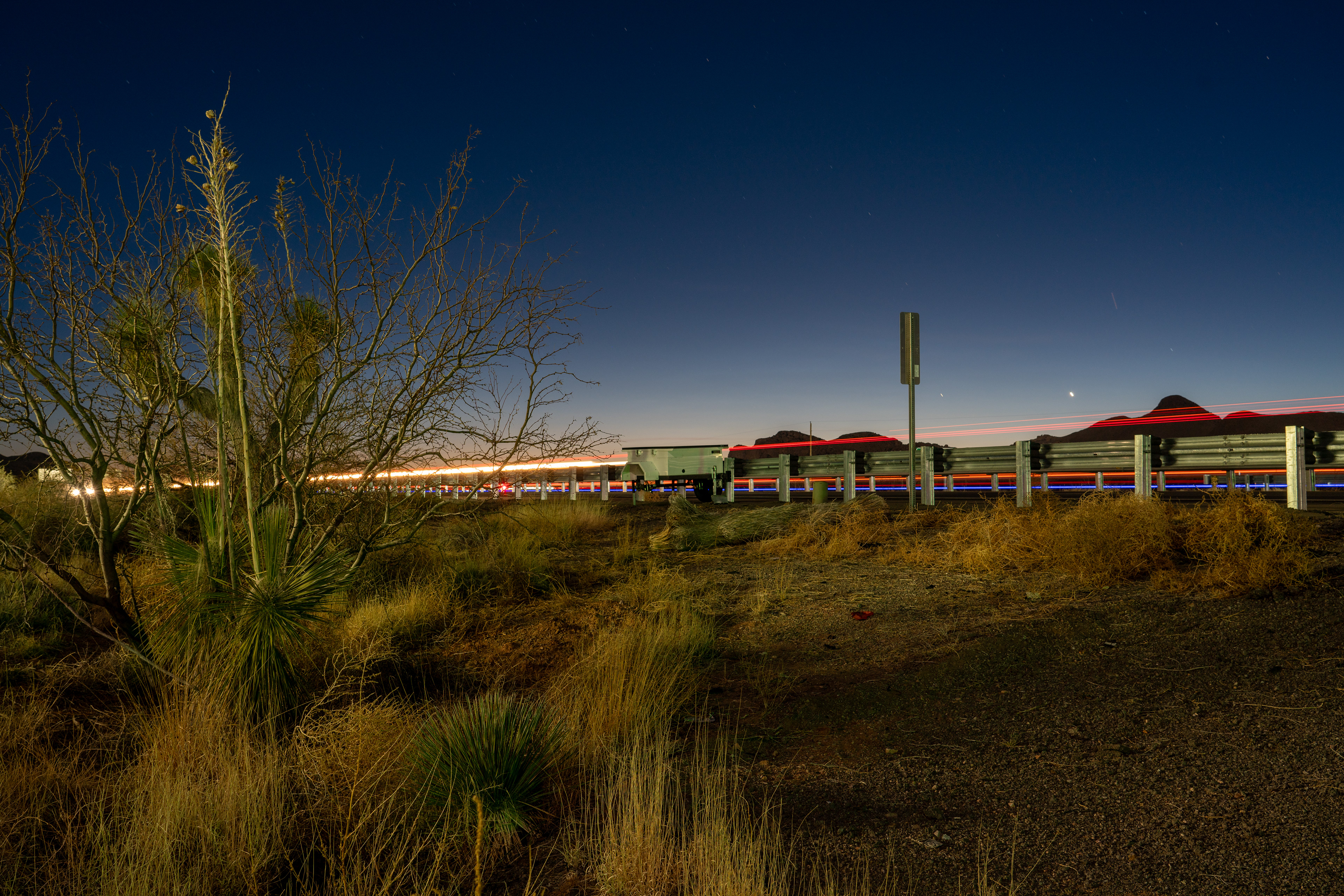
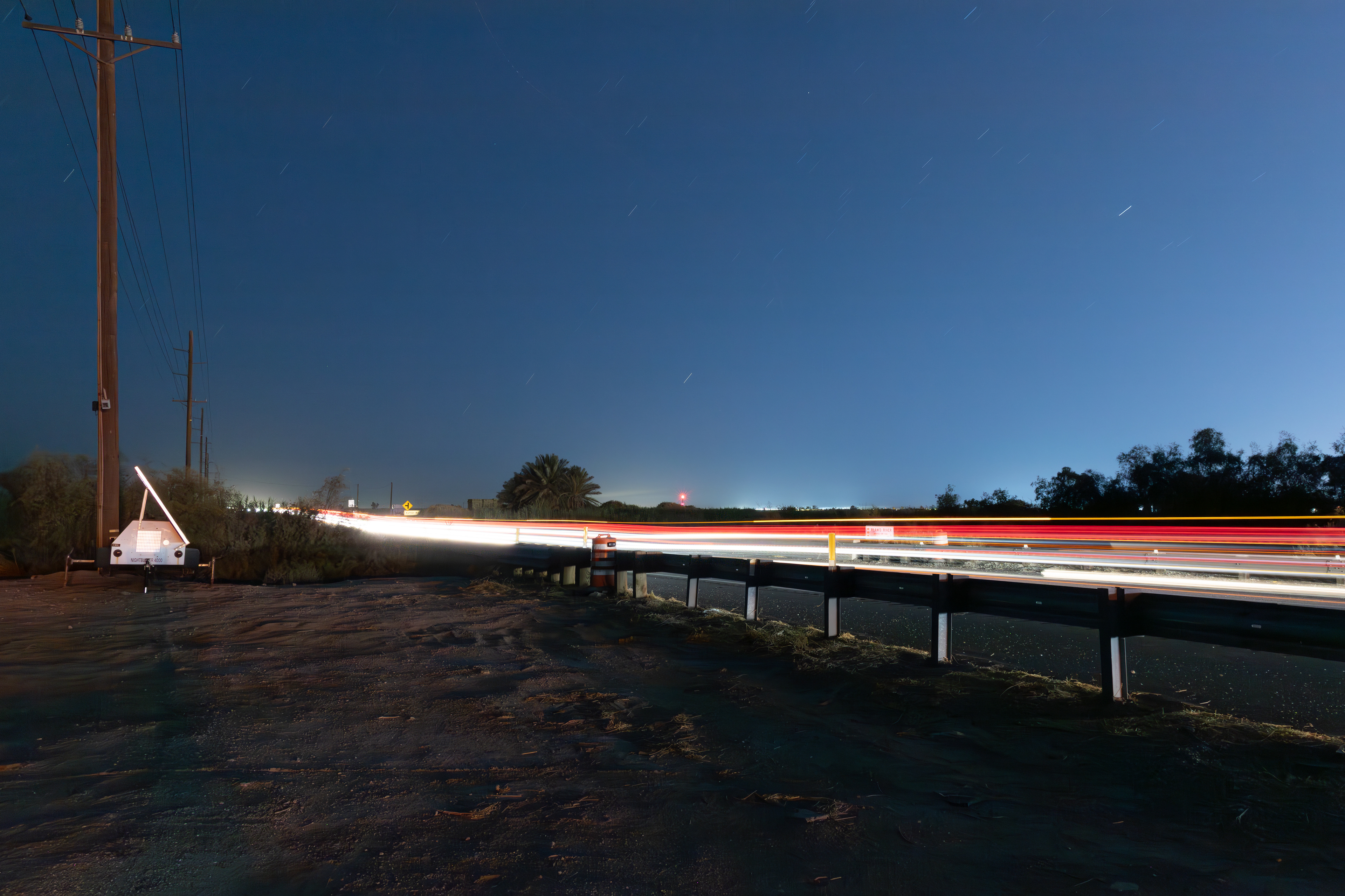
An automated license plate reader (ALPR) system disguised as a traffic construction barrel on the east side of westbound Interstate 8 in Boulder Park (east of Jacumba and west of Ocotillo), California, at 32.656306, -116.098472; Digital photograph; September 2024.
Automated License Plate Readers (ALPRs) are widely used throughout the US borderlands and, increasingly, in communities all across the country. Along the southern border, ALPRs are deployed in a variety of ways: increasingly integrated into police vehicles themselves, stationary deployments of the technology at Border Patrol checkpoints, ports of entry, and alongside highways and roads throughout the region remain common. Sometimes the technology operates from specially made trailers, two-wheeled units that can be pulled behind vehicles via hitch and then parked, like the portable security camera units increasingly ubiquitous in retail parking lots. In other cases, they are disguised as other objects, like traffic construction or impact attenuator sand barrels. The majority of the ALPR deployments encountered in this region outside major population centers are operated by U.S. Customs and Border Protection (CBP), which contains the U.S. Border Patrol, or the Drug Enforcement Administration (DEA), and these two agencies have an ongoing partnership to "leverage each other’s strategically located [ALPR] systems (CBP 2017: 4). However, state, county, and local police agencies also use ALPRs and may share data or intelligence derived from this technology.
CBP refers to disguised deployments as Covert LPRs, and in a 2017 Privacy Impact Assessment says that they are placed "at known smuggling routes and other areas of interest" and are "designed to be used for a set period of time while CBP is conducting an investigation of an area or smuggling route [and that] once that investigation is complete, or the illicit activity has stopped in that area, the covert cameras are removed" (CBP 2017: 5). As I have argued elsewhere (Meyer 2021), security is a political project—and an industry—always in need of an enemy. This is why while police budgets keep growing, they never seem to get any closer to actually winning their war against "illicit activity". Security is invested in insecurity. Instead of actually eradicating the threat objects it claims to oppose, policing is about administering them, perpetually restaging and repositioning the specters of insecurity just beyond reach but close enough to frighten the population into writing their checks. So it should be no surprise that many of these ALPR systems are never removed—in fact I have found covert ALPRs visible on Google Street View in the same spot they are today going back as far as 2012.
CBP refers to disguised deployments as Covert LPRs, and in a 2017 Privacy Impact Assessment says that they are placed "at known smuggling routes and other areas of interest" and are "designed to be used for a set period of time while CBP is conducting an investigation of an area or smuggling route [and that] once that investigation is complete, or the illicit activity has stopped in that area, the covert cameras are removed" (CBP 2017: 5). As I have argued elsewhere (Meyer 2021), security is a political project—and an industry—always in need of an enemy. This is why while police budgets keep growing, they never seem to get any closer to actually winning their war against "illicit activity". Security is invested in insecurity. Instead of actually eradicating the threat objects it claims to oppose, policing is about administering them, perpetually restaging and repositioning the specters of insecurity just beyond reach but close enough to frighten the population into writing their checks. So it should be no surprise that many of these ALPR systems are never removed—in fact I have found covert ALPRs visible on Google Street View in the same spot they are today going back as far as 2012.
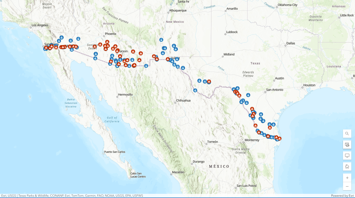
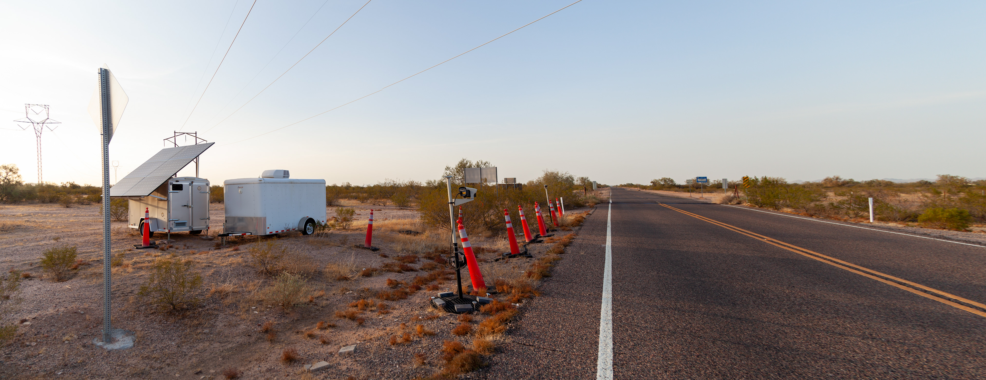
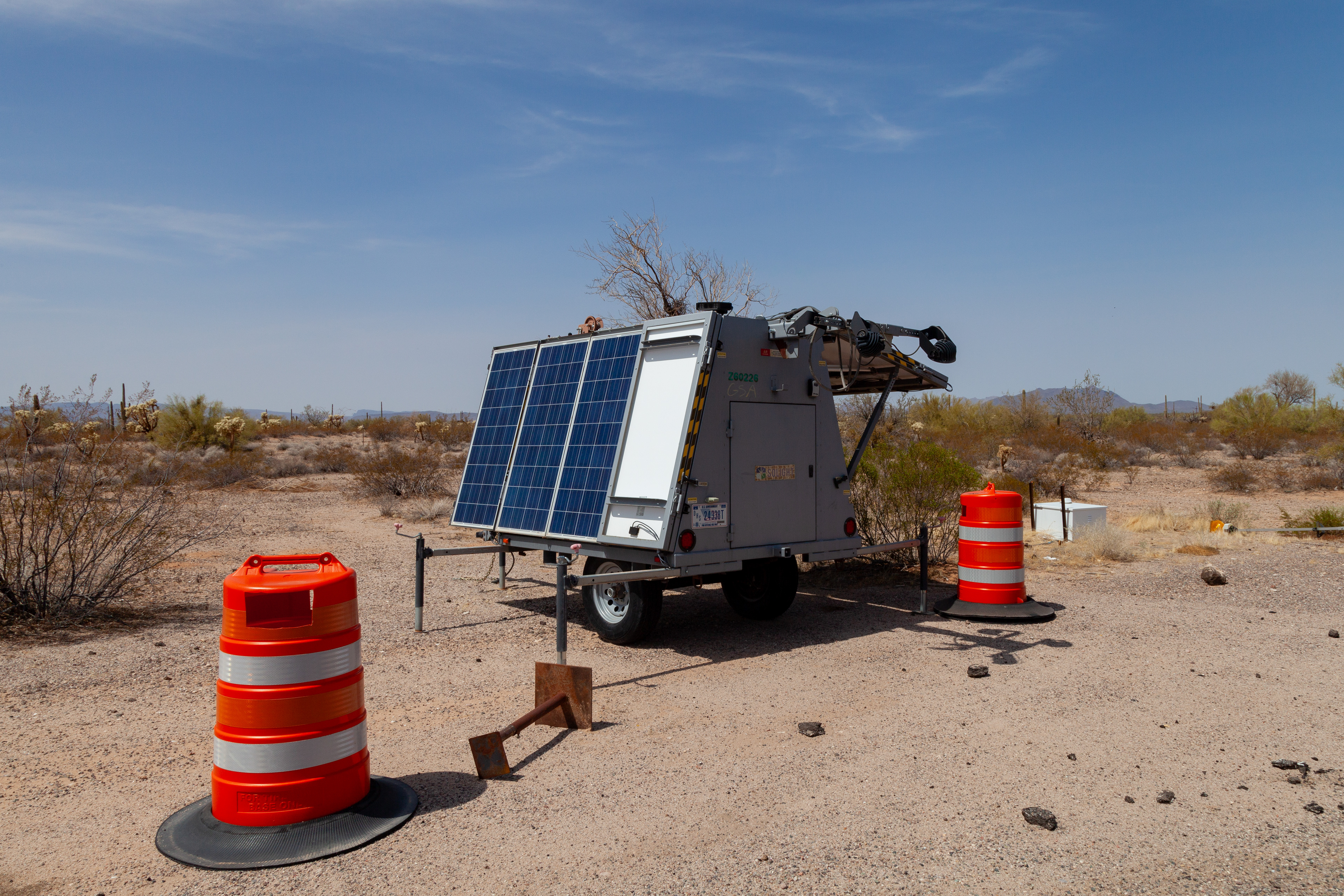
As of 25 November 2025, I have located and mapped 85 ALPRs across California, Arizona, New Mexico, and Texas. The Electronic Frontier Foundation (EFF), with whom I am collaborating on the first public map of these technologies, has found many others as well, bringing the total number mapped to more than 200. They are positioned on residential roads, county and state highways, and interstates. A separate power unit typically sits a few yards from the ALPR itself (this is also sometimes concealed), and remote "trail" cameras are often positioned nearby to surreptitiously watch over the equipment. Many have been operating in the same spot for years. Besides a few systems operated by state police agencies, none display any information identifying the police agency to which they belong.


Top: Two automated license plate reader (ALPR) systems disguised as traffic construction barrels on either side of California State Route 98 / Yuha Cutoff in Mt. Signal, California (west of Calexico), at 32.678417, -115.674417 and 32.678333, -115.674250. A solar panel providing power to the system is also visible on the north side of the road. Bottom left: A remote "trail" camera guarding the setup on the south side of the road. Bottom right: A closer look at the ALPR unit on the north side of the road. All images are digital photographs made in September 2024.


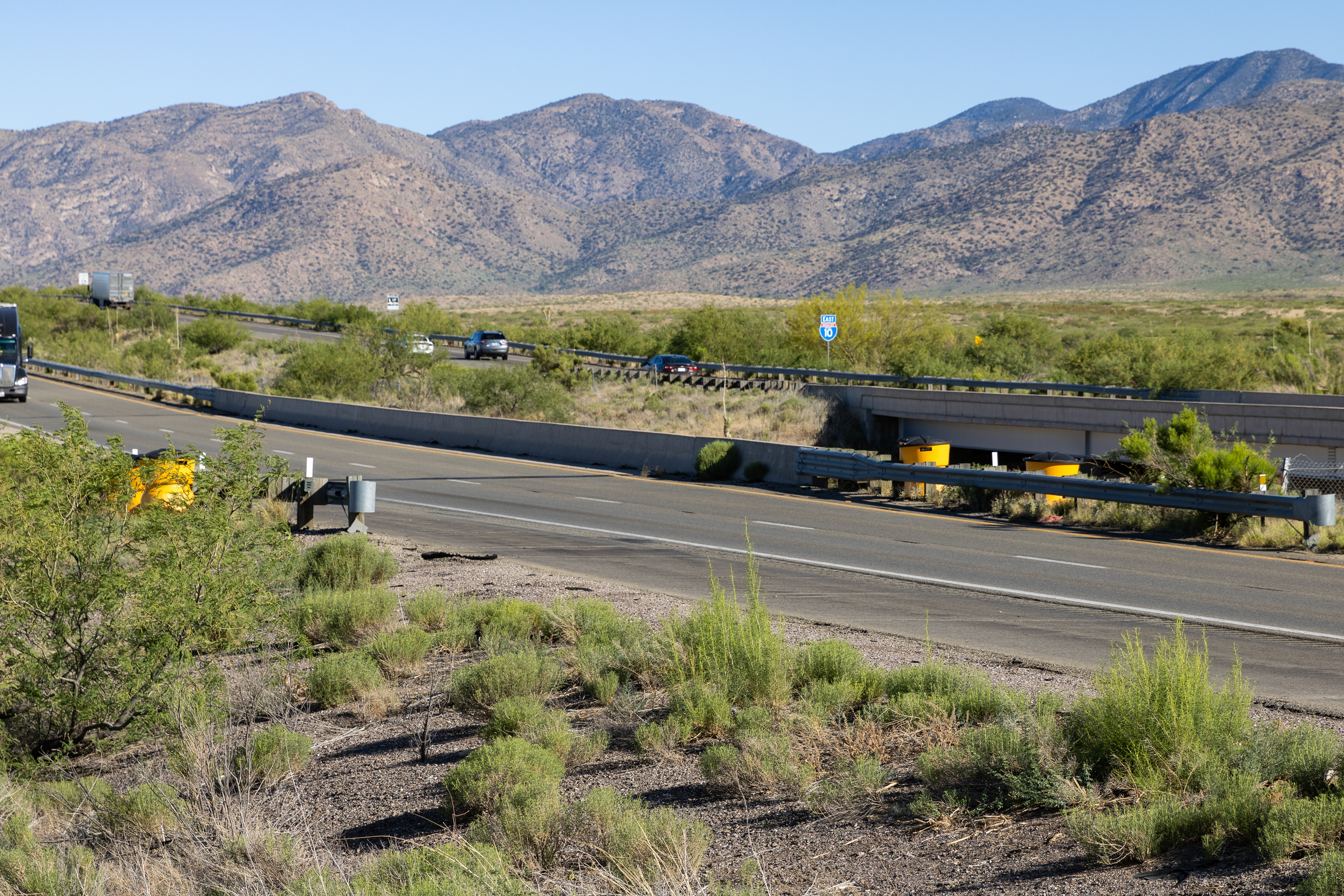
An automated license plate reader (ALPR) system operating out of a small trailer and positioned beside eastbound Interstate 10 about 5.3 miles east of the Arizona-New Mexico border near Roadforks, New Mexico, at 32.233635, -108.960571; Digital photographs; March 2025.


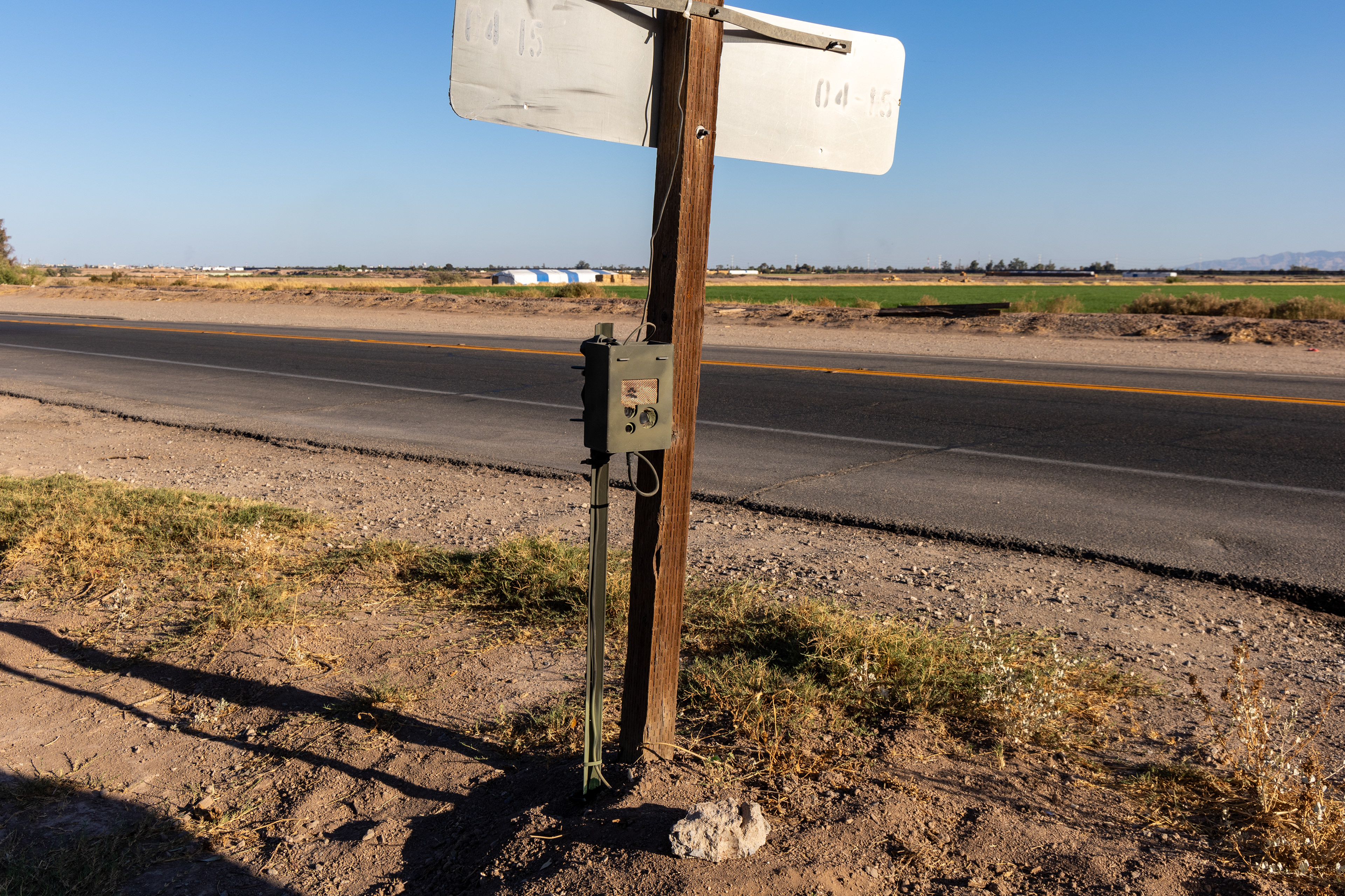
Top: Automatic license plate recognition (ALPR) units disguised as impact attenuator sand barrels on either side of westbound Interstate 10 between Bowie and Wilcox in Cochise County, Arizona, at 32.357389, -109.612556 and 32.357602, -109.612563; Bottom left: A utility box attached by wires to the ALPR on the north side of the highway, located a few meters away down an embankment; Bottom right: A remote "trail" camera positioned nearby to watch over the utility box. Another remote camera surveilling the site is visible in the first image attached to the guardrail on the left. All images are digital photographs made in May 2024.


Top: Two automated license plate reader (ALPR) systems—one disguised as a traffic construction barrel and the other in a raised box attached to a trailer with a solar panel providing power to the units—on the north side of California State Route 98 in Calexico, California, at 32.679361, -115.549806 and 32.679361, -115.549778. Bottom left: A closer view of the ALPR system attached to the trailer. Bottom right: A remote "trail" camera positioned at the base of a street sign nearby to surveil the site. All images are digital photographs made in September 2024.


Top: Two automated license plate reader (ALPR) systems on the west side of Indian Route 42 / Stanfield Rd just south of Battaglia Dr and less than 300 feet outside the northern boundary of the Tohono O'odham Nation, at 32.767503, -111.963703 and 32.767377, -111.963711. This system is made by Selex ES Inc, a subsidiary of the Italian multinational military technology company Leonardo, and is likely operated by the Drug Enforcement Administration (see below). Bottom left and right: A closer view of one of the ALPR systems. All images are digital photographs made in March 2025.


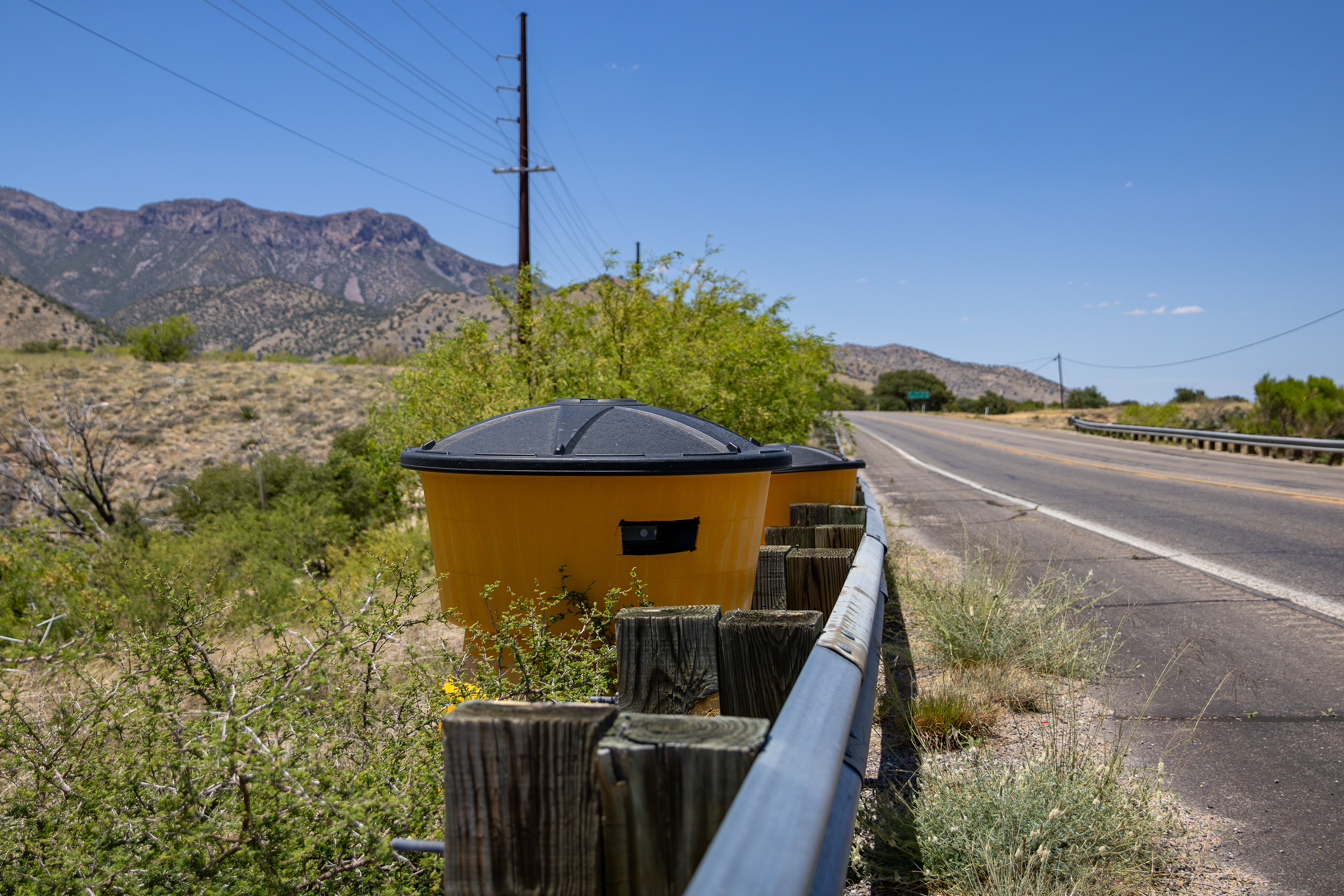
Two automated license plate reader (ALPR) systems—one pointing north and the other south—disguised as an impact attenuator sand barrel on the east side of Arizona State Route 79 / Pinal Pioneer Parkway about 14 miles northwest of Saddlebrooke in Pinal County, Arizona, at 32.723943, -111.110139; Digital photographs; April 2025.


U.S. Drug Enforcement Administration (DEA)-operated automated license plate reader (ALPR) system attached to the back side of highway signage on the southbound side of Interstate 10 in Eloy, Arizona, at 32.766467, -111.602410; Digital photographs; November 2025.


Two automated license plate reader (ALPR) systems, manufactured by Flock Safety, on the east and west sides of Chuichu Rd where it intersects with W Battaglia Rd just outside the northern boundary of the Tohono O'odham Nation, at 32.763292, -111.757204 and 32.763283, -111.757318; Digital photographs; March 2025.

Two automated license plate reader (ALPR) systems operating from a New Mexico State Police speed display trailer unit between the east- and westbound lanes of Interstate 10, 4 miles east of the Arizona-New Mexico state line near Steins, New Mexico, at 32.227198, -108.982082; Digital photograph; March 2025.


Two images of an automated license plate reader (ALPR) disguised as an impact attenuator sand barrel at the US Border Patrol checkpoint on Indian Route 15 southeast of Tat Momoli on the Tohono O'odham Nation, at 32.551293, -111.928953; Digital photographs; March 2025.


Top: An automated license plate reader (ALPR) system disguised as a traffic construction barrel on the southeast side of US Route 95 in Fortuna Foothills (northeast outskirts of Yuma), Arizona, at 32.706111, -114.434472. Bottom left: A remote "trail" camera affixed to the guardrail and surveilling the site (also visible in the top image). Bottom right: A trailer unit with solar panel providing power to the ALPR system positioned nearby down an embankment. All images are digital photographs made in September 2024.

An automated license plate reader (ALPR) system disguised as a traffic construction barrel on the south side of westbound Interstate 8 / Kumeyaay Highway just west of the Algodones Dunes in Imperial County, California, at 32.708806, -114.948750 (as of January 2025, another ALPR unit, also disguised as a traffic construction barrel, is situated nearby on the north side of the eastbound lanes of the highway); Digital photograph; September 2024.


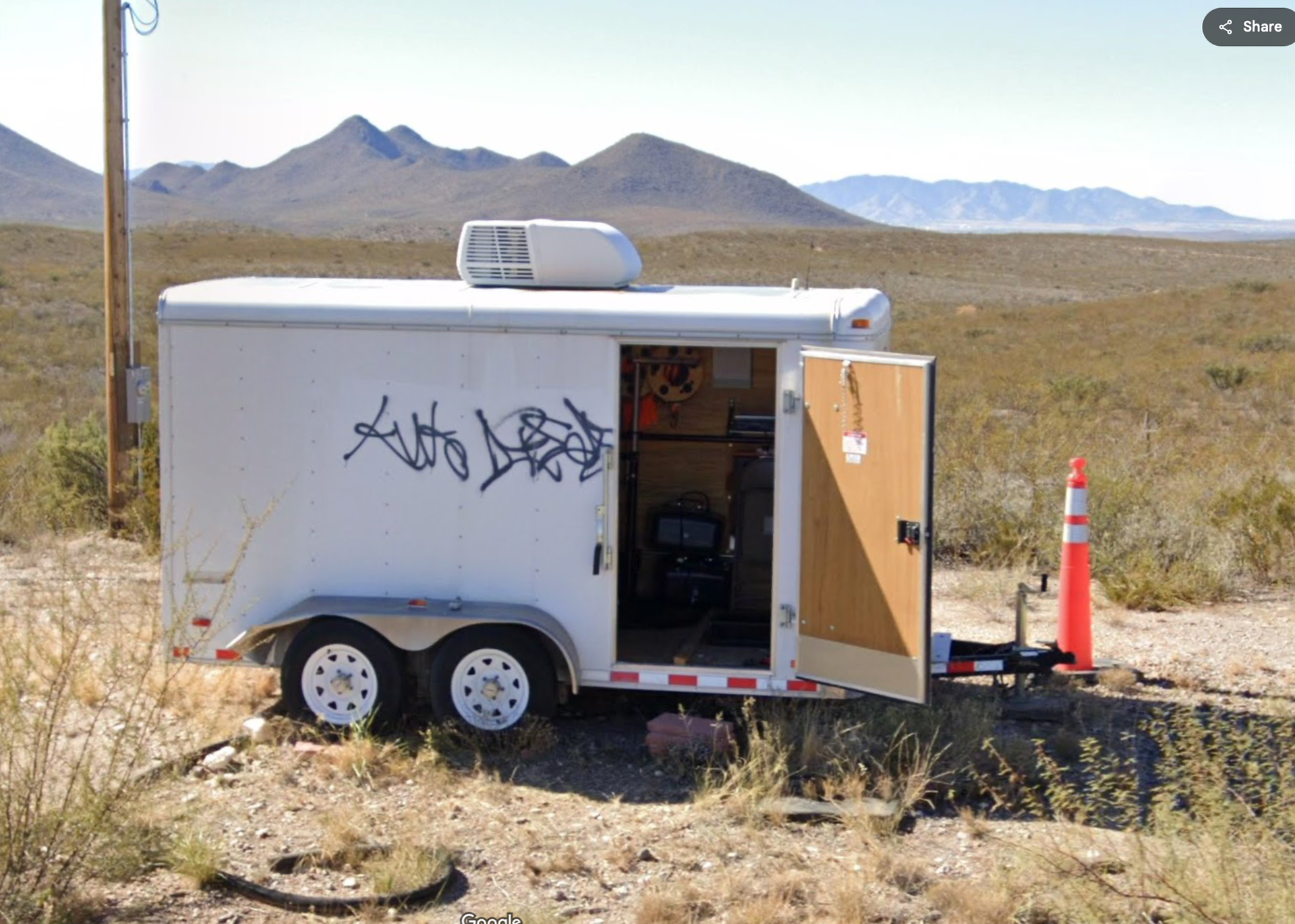
Top: An automatic license plate recognition (ALPR) unit disguised as an impact attenuator sand barrel on the southwest side of Arizona State Route 80 about 3,000 ft northwest of the Border Patrol checkpoint and just outside Tombstone, Arizona, at 31.754845, -110.104615. Bottom left and right: A locked utility box with a solar panel that is connected to the ALPR unit by partially buried wires is positioned down an embankment nearby. All images are digital photographs made in March 2025.


Top: Two automatic license plate recognition (ALPR) units disguised within a single impact attenuator sand barrel on the west side of AZ State Route 82 / E Patagonia Hwy between Nogales and Patagonia in Santa Cruz County, Arizona, at 31.473215, -110.820346. A locked utility box with a solar panel that is connected to the ALPRs units by partially buried wires is visible in the image at the top. All images are digital photographs made in May 2025.


Top row, left to right: 32.860083, -112.394611 (Interstate 8 near Big Horn, Arizona); 31.391300, -110.231795 (AZ-92 south of Sierra Vista, Arizona); 32.203207, -112.759158 (AZ-85 / N Ajo Sonoita Hwy south of Why, Arizona) [ALPR is on top of the trailer]; 31.821490, -106.704665 (NM-9 near Santa Teresa, New Mexico). Middle row, left to right: 32.026667, -107.861500 (Deming Aerostat Radar Site near Deming, New Mexico); 31.830694, -107.622250 (NM-9/Anapra Rd near Columbus, New Mexico); 32.632833, -116.934139 (Wueste Rd in Chula Vista, California); 32.203001, -112.759021 (AZ-85 / N Ajo Sonoita Hwy south of Why, Arizona). Bottom row, left to right: 32.644972, -116.932750 (Otay Lakes Rd in Chula Vista, California); 32.605333, -116.615000 (CA-94/Campo Rd in Potrero, California); 32.028249, -110.720139 (Interstate 10 near Vail, Arizona); 32.693806, -115.374639 (Bonds Corner east of Calexico, California).

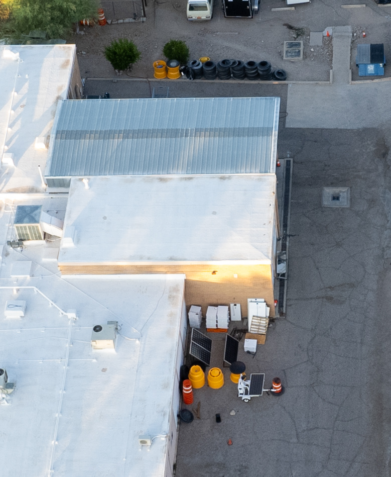
Covert ALPR workshop at the US Border Patrol Tucson Sector Staging Facility, a publicly unidentified facility located at 1936 W Ajo Way in southwest Tucson. This facility also houses many unmarked police vehicles used as part of Border Patrol and ICE operations in the city; 32.178710, -111.006920 (Tucson, Arizona); Digital photograph (and detail); June 2025.
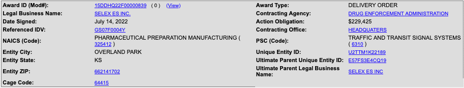
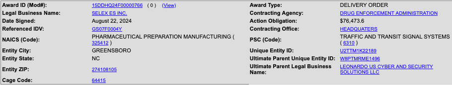
As mentioned above, part of my work in this area involves identifying the various ALPR technologies in use and the particular police agencies operating the deployments we find. One source of information is federal procurement records, available through the Federal Procurement Data System (FPDS) and USASpending.gov. The former is a real-time, relational database of summary-level information on contracts valued at $10,000 or more between federal agencies and the providers of technologies like ALPR. For example, here are two entries from the FPDS database for contracts between the Drug Enforcement Administration (DEA) and Selex ES Inc (a subsidiary of the Italian multinational military technology company, Leonardo) for ALPR technology:
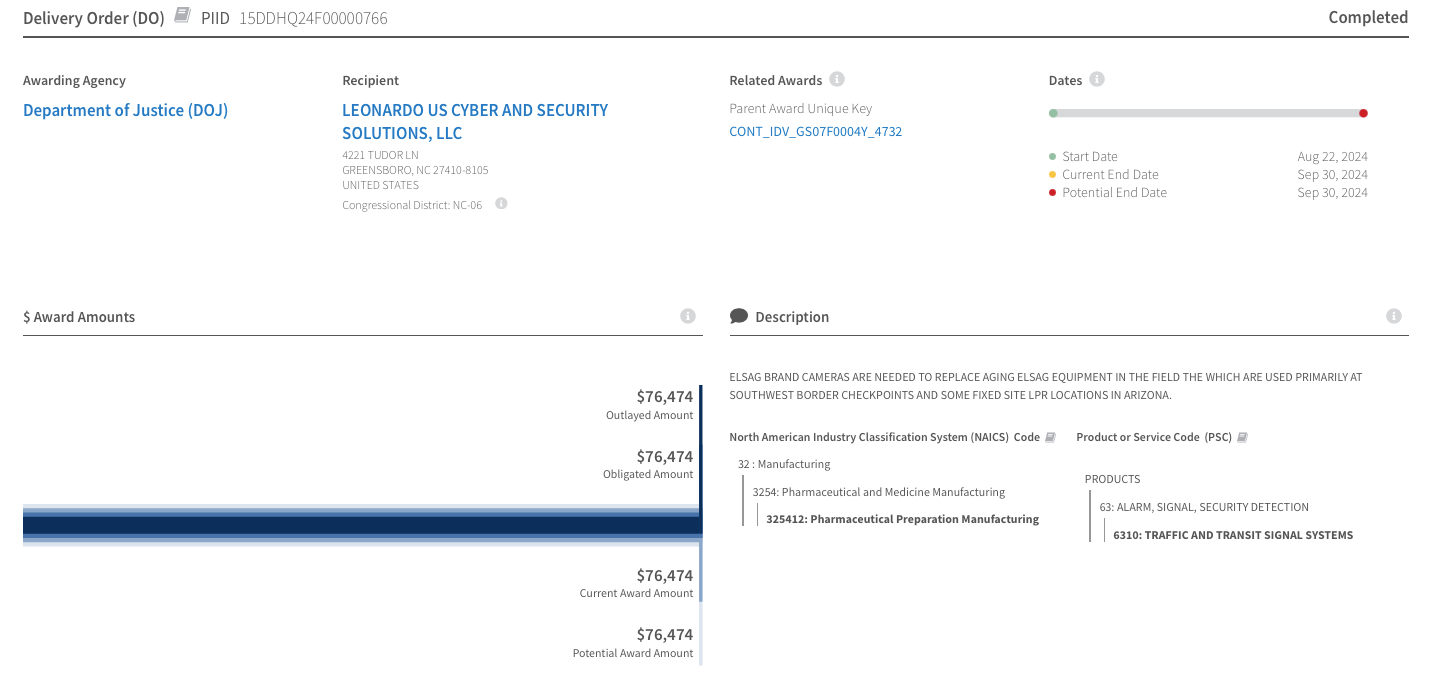
The FPDS is considered the authoritative source for information about government contracts. USASpending.gov derives its data from the FPDS database on a monthly basis and is designed to be a more user-friendly platform for static information on government contracts including graphs and charts. Here is a screenshot of the USASpending.gov contract award summary page corresponding to the 2024 contract described in the FPDS entry on the right above:
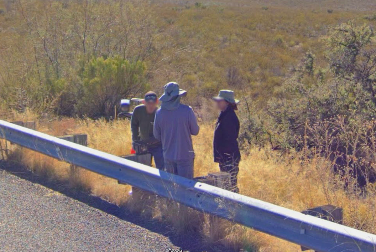
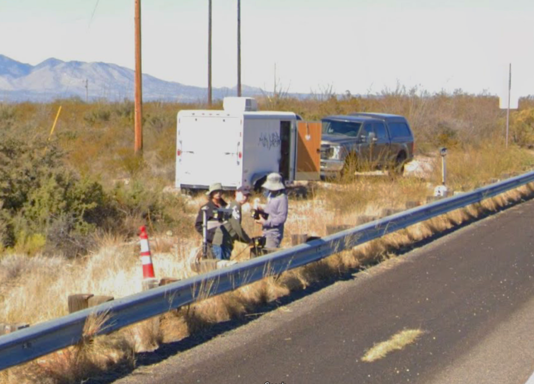
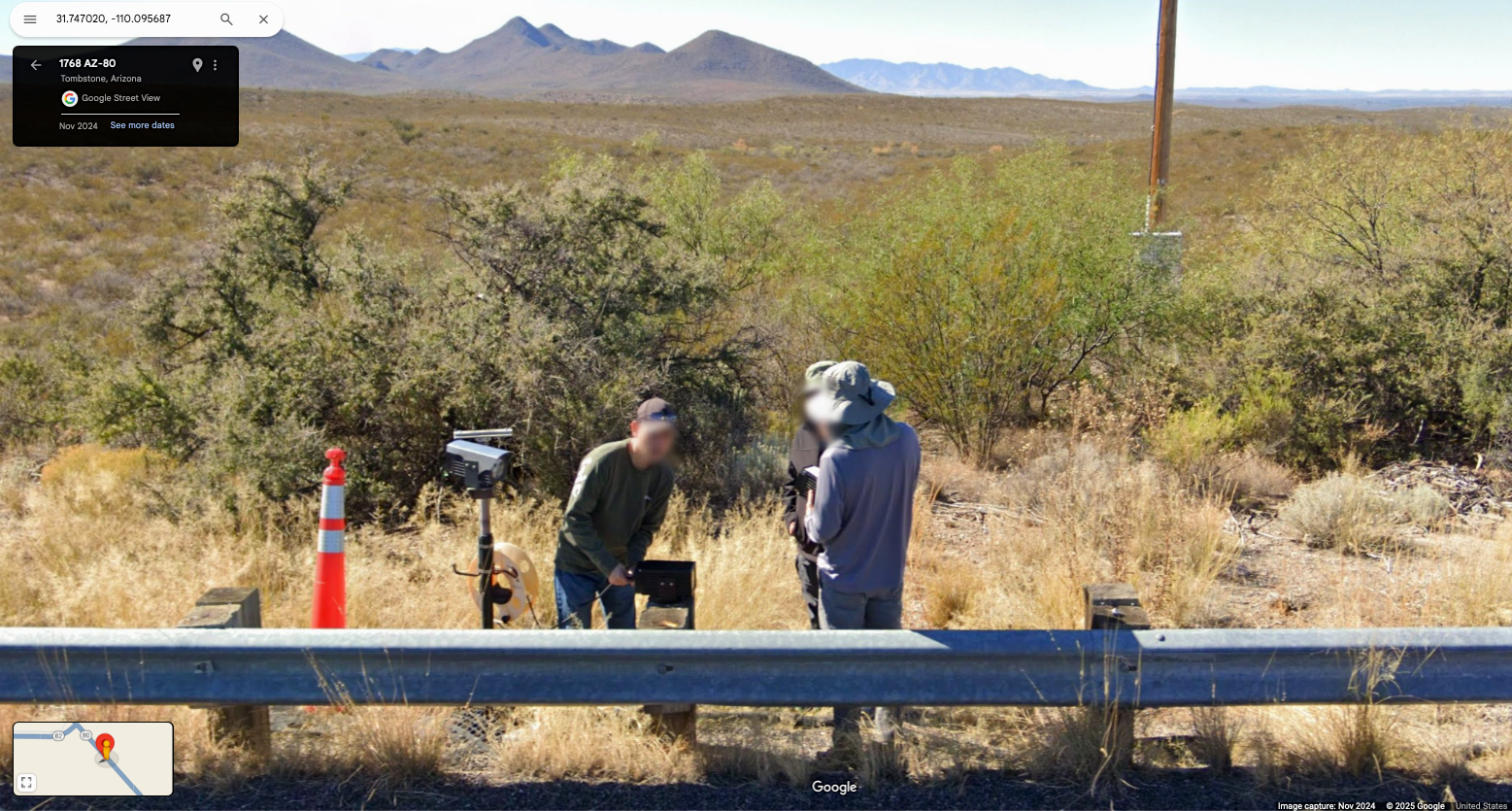
The images below are screenshots from Google Street View of an ALPR site near Tombstone, Arizona in November 2024. The three individuals pictured are dressed in plain clothes and are working out of an unmarked pickup truck. Because the ALPR system at this site is one of the Selex/ELSAG/Leornardo models and is located near a Border Patrol checkpoint (both of which are consistent with what we know from the contract records and the privacy assessment linked above), I suspect that these are DEA agents: