
Infrastructures of Control: Visualizing Security and Surveillance in the U.S. Borderlands is an ongoing collaborative project created by Colter Thomas and me. We do fieldwork research along the length of the U.S. border with Mexico to produce a visual archive of U.S. border security infrastructure. Guided by the Electronic Frontier Foundation’s publicly accessible map of U.S. Customs and Border Protection surveillance technologies—a map to which we are also contributing through our work—and other collaborations, we locate and study, through photography, mapping, and other methods, surveillance technologies and other forms of security infrastructure in a wide range of landscapes, from arid patches of desert to river deltas to small towns and bustling metropolises, residential backyards, public parks, college campuses, private ranches, military proving grounds, and more.
Some of my photographs from this project can be found here. Some of Colter's photographs can be found on his website here. You can read a short photo essay from our project in the Border Chronicle here (en español aquí), and a Q&A about what we do with Dave Maass of the Electronic Frontier Foundation here. Research is ongoing.
In April 2024 we organized the first exhibition of work from our project on the campus of the University of Arizona in Tucson. It included 30 photographs by Colter, a large map (made by Matt Marcus and me, using a dataset originally created by the Electronic Frontier Foundation to which Colter and I have been contributing), a 20ft. fabricated steel replica surveillance tower (made by Elliot Semonsky and Michael Ramirez), and an online exhibition guide featuring analysis, archival documents, fieldnotes, additional images, bibliographies, and other materials corresponding with the photographs on display.
In October 2024 we are showing another exhibition of photographs by both Colter and me as part of Regardless of Frontiers: The First Amendment and the Exchange of Ideas Across Borders, a symposium organized by the Knight First Amendment Institute at Columbia University in New York City. The online exhibition guide is available on our project website, www.infrastructuresofcontrol.com.
We collaborate with many others. Our work so far has been funded by the Confluencenter for Creative Inquiry and the Mellon Foundation, as well as the W.A Franke Honors College; the Graduate & Professional Student Council; the School of Geography, Development & Environment; and the Binational Migration Institute at the University of Arizona.
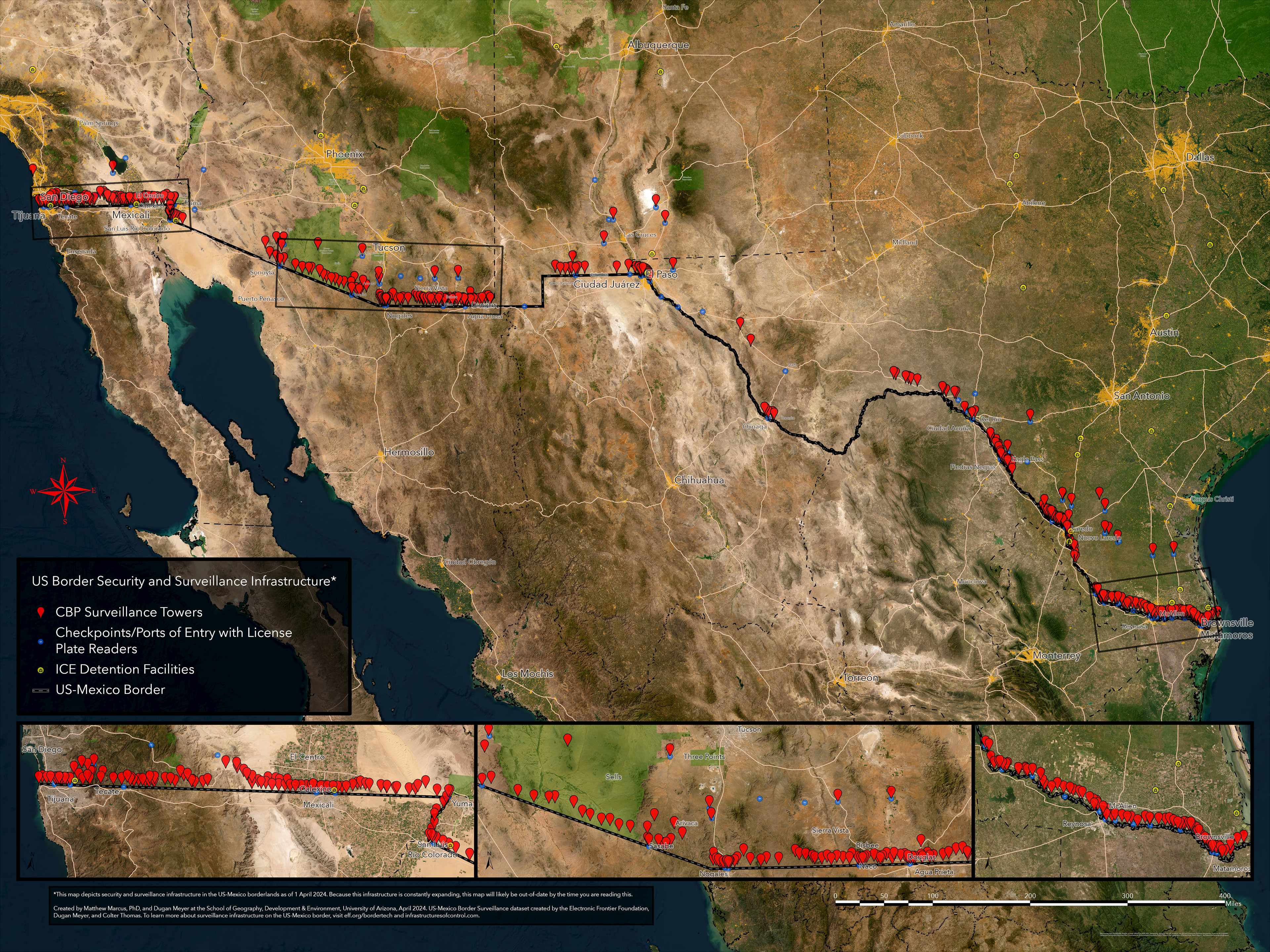
A map made by Matthew Marcus, PhD, and me for the first project exhibition in April 2024.